The ability to expand and diversify our skill set is critical to meeting the changing needs of our clients. The MWH surface water team in Western Australia recently expanded their hydraulic modelling capability, bolstering their position as a market leader in hydrologic and hydraulic modelling.
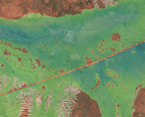
High-flow floodplain showing underlying aerial image and culverts along the linear infrastructure alignment.
Following a client request, the team was challenged with extending their existing hydraulic modelling capabilities (such as HEC-RAS, Mike 11, Mike 21 and InfoWorks RS) to undertake a flood study utilising the client’s preferred two-dimensional (2D) modelling software TUFLOW. The area of interest was in the vicinity of linear infrastructure within a significant and extensive floodplain in Western Australia.
The 2D TUFLOW model was utilised to simulate flood water progression over a Digital Elevation Model (DEM) surface, while incorporating one-dimensional (1D) elements such as levees and culverts.
Project highlights include:
- Over 1,000,000,000 points of 1 m Aerial Survey data for the generation of the Digital Elevation Models
- Model domain in excess of 170 km2
- More than 18 km of linear infrastructure
- In excess of 130 culvert locations, representing approximately 200 culverts within the linear infrastructure alignment
- 10 inflow boundaries and 1 outflow boundary
- Sensitivity analyses, including:
- Optimisation of DEM grid size against model run time and computational capacity
- Assessment of constant head inflow delivery vs hydrograph inflow
- Varying roughness coefficients (Manning’s n value)
- Varying 2D cell wet/dry coefficients
- Evaluation of a range of computational time steps; and
- Varying approaches for culvert configuration (1D and 1D/2D boundary setup)
- A total of 105 model runs, equating to approximately 840 hours (35 days) of straight computational modelling time
- Final delivery to the client culminated in the issue of 21 models, including six models for presentation and 15 sensitivity-run models for documentation in the study report
In addition to the accelerated adaptation required to build and run the TUFLOW software, the MWH surface water team also developed skills in running additional support software. These additional software packages were used to assist in the building of the TUFLOW model, or in the interpretation and display of the model outputs, and include ArcGIS, Quantum GIS (QGIS) and WaterRIDE.
With a strong commitment to consistently delivering client-focused outcomes, MWH undertook the project to assist the client in meeting a tight timeline for internal reporting and completed the project on time and within budget.
Should you wish to know more about our Surface Water modelling capabilities, please contact the Surface Water discipline lead Johan Van Rensburg, on (08) 9211 1404 or at Johan.vanRensburg@mwhglobal.com.


